

- Explore Norfolk
- Norfolk Walks
- Circular Walks in Norfolk
- Pingo Trail
The Pingo Trail Walk
The Pingo Trail walk is a really extraordinary and fascinating walk in Mid Norfolk, just north of Thetford in the heart of The Brecks.
I expected to see a few Pingo ponds, but nothing like as many as there were.
This part of Norfolk has the highest density for Pingo ponds and I can guarantee you certainly won’t be disappointed with what you’ll see. Pretty much everywhere you walk, there’s water!

Along with the very picturesque Thompson Water, a man-made lake, this is a very picturesque walk in amongst marshy woodland and wetland, walking on part of an old Roman Road called the Peddars Way and across Thompson Common and finally finishing up along a disused railway line where you pass some incredible beautiful swamps.
What are Pingo Ponds?
Before I get on to this Great Eastern Pingo Trail walk, let me just quickly explain about Pingos because you’ll be walking amongst a bit of history here.
Also known as kettle ponds, these pingos date back to the ice age, and Pingo is the Inuit word for “hill”. As the glaciers retreated, they left hard masses of ice which eventually had soil over them. Then, as the climate became warmer and the ice melted away, the soil on top formed depressions, leaving a hole filled with water – hence the Pingo was formed.
 Pingo Ponds
Most of the Pingos that were in the Brecks area have now disappeared due to the land being ploughed up for farming, so the ones remaining are historically, ecologically and internationally important for the wildlife.
The Pingo Trail Circular Walk
Length: just under 8 miles
Ease of Walk: easy and flat
What you’ll see: Pingos, long horned cattle, woodland and common land, wetland and swamps, Thompson Water, water violets
Dogs: Dogs are allowed on this walk but they must be under control, especially on Thompson Common
Postcode: NR17 1DP
OS Map: No 229 (advisable)
For a downloadable pdf of the The Pingo Trail map, click here.

Great Eastern Pingo Trail Map
The Pingo Trail
If you want to see what's in store for you before you go, why not check out the video below! I walk you around the trail in 10 minutes!
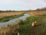
The Pingo Trail starts in the car park off the main A1075.

This was the old site of the Stow Bedon railway line (part of which you’ll walk on towards the end). As you drive along the main road, about 3 miles south of Watton you’ll see a largish lay-by. You can park here if you wish, but the actual car park is just behind here, so take the track in the middle of the lay-by and turn immediately right.
Most of the walk is very well sign posted. You occasionally have to keep an eye out for way markers, but Norfolk Trails have upgraded the posts, so you shouldn't have a problem.
The start of the Pingo Trail is through a kissing gate and the path is very obvious along here.

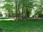
If you start this way first, it’s quite exciting because you come across the first Pingo pond fairly early on as you walk through the woods and the first stretch of Thompson Common. Some of these ponds were stagnant, others had pretty water violets.
As I came out of the first wood and faced a very open Pingo, I wondered which way I should go until I saw a sign to my right. I skirted the pond and quickly found a well-trodden track which I followed.


A little bit further on I another found a sign as well as some interesting long horned cattle. Luckily they didn’t seem to be bothered with me which was a great relief, as I do have a slight fear of walking through fields with cows! They had very impressive horns though and were a lovely sight!!

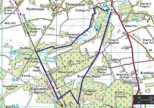
From here you continue along the path and over the common land until you reach a junction with fairly open land on your right hand side. This is probably the one place where you need to be alert as I did slightly wonder which way I should go (this is why it’s always advisable to have an OS map with you!).

Here you need to go through the gate and follow the path through more woodland. If you're chattering away, you may miss this and continue on around the woods.
Eventually you reach a very quiet tarmac lane. Turn left to continue along this road, past a few cottages until it turns into a track straight ahead. Carry on along the track, passing more Pingos, and more open common land.
I had a lovely treat watching this fox run in front of me, and then had the pleasure of seeing it again as I neared the end of the walk. It hadn’t gone far during the time it took me to walk the 7 or so miles but because the last stretch is parallel to where I was walking earlier, it had just walked across these two tracks!

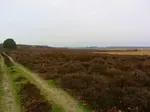
Once past this stretch of open meadow, you’ll have a very pretty walk in amongst woodland and alongside a stream and eventually arriving at more Pingoponds and then the wonderfully picturesque Thompson Water.
Norfolk Walking Books
- The 16 Coastal Dog Walks book is very dog friendly, as I wanted to discover walks that didn't require much road walking or time on leads. They are all around the Norfolk Coast.
- The Norfolk Heritage Walks book contains 18 walks with an interest. The walks are dotted all around Norfolk depending on where there is something fascinating to visit, be it a priory ruin or castle ruin, a stately home, windpumps or lighthouses and more.


Thompson Water On The Pingo Trail
There’s a small bird watching hide overlooking Thompson Water surrounded by lots of bird feeders hanging from the trees, and it’s definitely worth stopping at, not least to rest your legs! The view over the lake is beautiful and you’ll probably catch sight of the resident swan just beneath the hide. I had the joy of watching a kite scanning the area and seeing the sun glistening on the water.
Other great bird watching walks can be found here on our coastal and inland walks page.
 The view from the hide overlooking Thompson Water
The lake used to be dominated and almost completely covered with a plant called Water Soldier, and although it provided ideal habitat for a lot of wildlife, it also takes the oxygen out of the water. The Norfolk Wildlife Trust has therefore worked closely with Natural England and the Environment Agency to work out the best option for this plant. It is now fairly clear.
Thompson Water is actually a man-made lake which was created in 1845 along a tributary of the River Wissey, and has nothing to do with the Pingos!
ACCOMMODATION SUGGESTION NEAR THE PINGO TRAIL
A great 1 bedroom holiday cottage in the nearby village of Thompson - Deer Cottage with a secluded and private garden along with a hot tub.

Another mere that you may like to walk around is Horsey Mere on the Horsey Windpump Circular walk.
Thompson Water is a lovely spot to stop before you start on the next stretch of the walk on a wide farm track. This is now part of the Peddars Way Long Distance Trail.

You continue along the Peddars Way track which then turns into a tarmac lane. Continue up the hill and bear left, (leaving the Peddars Way which bears right). There is a Pingo Trail sign at the top of the hill so it's quite easy to see! Bearing left, walk down the slight incline, and at the bottom of the hill you'll see another sign on the left hand side pointing to the left. Follow the path through the hedge and walk straight ahead where you'll then come to another small fence and steps which take you down to the disused railway.
Turn left here for yet more glorious views and wetlands!

Cranberry Rough
I really enjoyed this next section of the walk. You meander through Cranberry Rough where on either side you’re surrounded by water and wetland, dykes and pools. It’s a fantastic sight full of water violets and trees in swamps. It would be quite fun to take a little boat and row your way around here!

This area is a Site of Special Scientific Interest because of the pollen and the plant remains in the peat which is below all this wetland. (West Runton beach is also an SSSI).
 The swamps of Cranberry Rough
Once through Cranberry Rough, you then follow the straight disused Thetford to Swaffham railway track for a while, along open farmland, and this path eventually takes you all the way back to the car park.
 Cranberry Rough
It really is a fascinating walk with so much to see. I just remember thinking “water, water everywhere”! It’s quite a long walk, but I would highly recommend it. It took me about 2 ¾ hours, with a slightly niggly back, but it is definitely a walk I would do again.
P.S. I have done it quite a few more times and each time I love it more than the last time!
Other Inland Walks You May Like
Roydon Common Circular Walk
Roydon Common circular walk is a lovely 5.5 mile amble over the open heath land, along a stretch of disused railway and the countryside of North Norfolk
Castle Acre Circular Walk
This Castle Acre circular walk is a dog friendly 6 mile stroll along the picturesque River Nar, open countryside and woodland passing Castle Acre Priory
Walsingham Circular Walk
Walsingham Circular Walk is a perfect excuse to visit Walsingham Priory, walk through the historic village and follow in the footsteps of the famous pilgrims
Foxley Norfolk, Norfolk Wildlife Trust Bluebell Wood Spectacular
Foxley Norfolk, home to one of the most spectacular bluebell woods in UK run by Norfolk Wildlife Trust. The largest remaining block of ancient wood in Norfolk
Felbrigg Hall Walks
Felbrigg Hall walks are countryside and woodland walks. Experience a V shaped wood, an ancient ice house, an extraordinary church interior and a beautiful lake

WONDERING WHAT TO DO IN NORFOLK?
Download your free copy of the "Quick Guide To Norfolk Beaches" and join our newsletter to keep up to date with 4 different tips every month for enjoying what Norfolk has to offer.
- Explore Norfolk
- Norfolk Walks
- Circular Walks in Norfolk
- Pingo Trail
KEEP UP TO DATE
Get your free copy of the "Quick Guide To Norfolk Beaches". Find out more about our monthly newsletter here

Inland and Coastal Walks
Castle Acre Circular Walk

Felbrigg Circular Walk

Felbrigg Hall Walk In Grounds

Foxley Wood

Roydon Common

The Pingo Trail
Coastal Walks
Holme Dunes

Stiffkey to Wells

Cley Marshes

Cromer Lighthouse

Cromer to Roman Camp

Horsey Windpump

Hunstanton Circular Walk

Norfolk Walking Holidays
Information
Email: suzy@explorenorfolkuk.co.uk
Tel: +44 (0)1760 390 157
+44 (0) 7765 668188
Address: Explore Norfolk UK
Moore's Farm
The Street
Hindolveston
Norfolk
NR20 5DG
Enquiry Form
Terms and Conditions
Frequently Asked Questions
Norfolk Coast Path Walking Holidays

Peddars Way Walking Holidays

Peddars Way and Norfolk Coast Path Combined Walking Holidays

Norfolk Walking Blogs
My Norfolk Coast Path Blog

My Peddars Way Blog


Copyright© explorenorfolkuk.co.uk; 2013- All Rights Reserved