

- Explore Norfolk
- Coastal Walks
- Cromer To Roman Camp Circular Walk
Roman Camp Circular Walk, North Norfolk
There are all sorts of circular walks you can take around the Roman Camp at Beeston Regis on the North Norfolk coast, but this particular one starts out of Cromer and takes you up into the woodlands above Beeston Regis following the old Norfolk Coast Path and onto the Roman Camp, alongside Incleborough Hill, down into East Runton, and back into Cromer. It’s a great walk for those that have come to Cromer by public transport as it means you can take a lovely bracing walk without the need for a car.

It’s also an excellent day walk – you could take a picnic with you, stop on the top of Roman Camp, eat and admire the view, and then wander back down to Cromer.
The Roman Camp Circular Walk
Length: 6.25 miles
Ease of Walk: Moderate, there is a climb up to the top of the Roman Camp, and Incleborough Hill if you wish, but once up, there’s only ever one way back, and that’s down!
What you’ll see: views over the North Sea, woodland, heathland, golf course, views towards Cromer from Incleborough Hill, crossing over railway line, fields and open countryside.
Map: OS Explorer 252

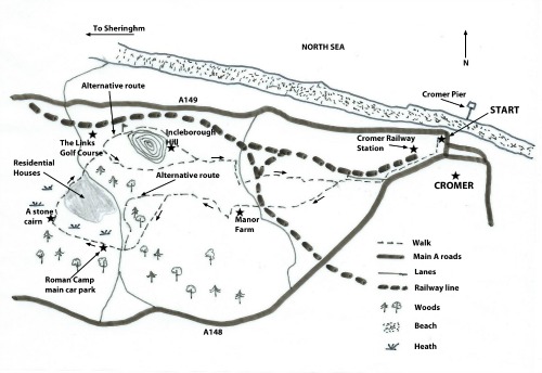

This particular walk starts from the car park on Beach Lane, Cromer.
Walk out of the top corner of the car park furthest away from the sea and turn left heading toward the main A148 Holt Road. Turn right when you reach this road (a small roundabout), and head up the hill passing Cromer Railway Station on your right. Once at the top of the hill, take the first right (Sandy Lane) and walk along this residential road until you reach the T junction. Go straight over and onto a wide well signed footpath. This is where you can really start to enjoy the walk.
Some of this walk follows the circular walk that is well signed, but it doesn't follow all of it so don’t get carried away with following these particular signs!

Carry along this track, walking past a camp site and admiring the views over to the wooded hillside in front of you. Walking along this path you begin to leave the noise of Cromer behind you.
Walk under the railway bridge, cross over the quiet lane and head straight on along the path in front of you. Just a bit further along here the larger track bears left, with the smaller narrower track heading straight on. (Left is private, you’ll see a sign). Take this narrower track which eventually brings you out at a pleasant grassy triangle with a couple of benches and a well marked signpost.

Sitting on the bench, you can see a well trodden path straight ahead of you, across a small bit of common land. Follow this track and the direction of the sign that says Sheringham 3 miles. Don’t walk left or right along the lane.
Once across this common land you’ll come to a kissing gate. Go through here, carry on along the path, go through another gate and very shortly after that you’ll reach a cross roads of tracks with a camp site just ahead of you to your right.

Take the left hand path to a gate with a metal weight hanging down from it. (You could alter this walk now by carrying straight on along the path and up through a wide woodland path which is very pleasant and takes you up to exactly the same spot as this walk will take you to – this alternative way is slightly easier).
If you choose to carry on with this particular walk then head straight across the field and up through the woodland along the obvious path. This is quite narrow but very pretty too. This way is definitely shorter than the alternative route, but a bit steeper and a bit more difficult under foot.
Once up at the top of the hill you reach a small car park and a lane. Cross straight over this lane and head along the road towards the Roman Camp. There's a big National Trust sign. Once you reach another larger car park, if you look to your right you'll see a couple of benches with wonderful views looking out over to the sea. Why not have a break!

To continue, carry on along the path into more woodland, following the easy walking wide track until you reach a cross roads of paths. Turn right here, at the cairn, through a wooden barrier and onto the heath at the Roman Camp. You can admire the fantastic views, and there are yet more benches for you to take a breather!

For the walk however, continue straight ahead on the heath for a very short distance and then bear slightly right between heather and gorse, passing a couple of benches (one flat bench with the name Margaret on on your right hand side in amongst the heather).
Follow this small track heading down towards the woods. The track will eventually bring you close to houses.
Before you reach the houses, the track meets another track (a sort of T junction with a tree right in front of you). Turn left along this track, now keeping the houses on your right and continue along here, all the time keeping the houses on your right and keep going until you reach the tarmac road and a grassy triangle at Town Hill.

Keep to the left of the triangle, cross straight over the road and follow the wooden footpath sign (not the National Trust one on your right) until you reach a tarmac road with a campsite and a traffic barrier on your right and the golf course on your left. Turn left here but take an immediate right along a small footpath which will take you alongside both the golf course and the campsite. Beautiful views over the golf course towards the sea. Eventually you’ll arrive at a tarmac road heading into the campsite with a WC brick building for the campsite on your left. Cross over the road and head along the narrow footpath (well signed).
This track takes you to the surrounding area of Incleborough Hill. Further along this path you’ll see some steps up to the top of Incleborough Hill – well worth taking a little detour to see the lovely view over towards Cromer.
Retrace your steps down the steps and instead of turning left and carrying on along the path you were on, go straight ahead, through the kissing gate and then another gate with a heavy weight on it. Cross the open field and walk between the hedge and the fence. Once at the end here, carry on straight, don’t turn right or left onto one of the other footpaths. This brings you out into East Runton.
Walk straight ahead and onto the lane. Keep the row of houses on your right and a playground with swings on your left. Follow this lane around to the right to the T Junction where you turn right. Continue along this road until you near the end of the village. On the left you’ll see a driveway with house signs for Home Hill, Driftwood, Strome and Buddleias.

Turn left up here and walk towards the house in front of you. Here you'll see a very narrow track between the side of the house and a hedge. Don’t take the left hand track before this house which is obviously for the other houses on your left. Take this narrow track that will bring you to a railway track (the main line so be careful).
Cross over the train track and follow the path to the left and then up the hill alongside the field, admiring another spectacular view over to the sea. Carry on along this path all the way to where you first joined the track after the residential Sandy Lane. Walk back to Cromer along the same road you started on.
 The heath at the top of the Roman Camp
KEEP UP TO DATE
Get your free copy of the "Quick Guide To Norfolk Beaches". Find out more about our monthly newsletter here

Inland and Coastal Walks
Castle Acre Circular Walk

Felbrigg Circular Walk

Felbrigg Hall Walk In Grounds

Foxley Wood

Roydon Common

The Pingo Trail

Coastal Walks
Holme Dunes

Stiffkey to Wells

Cley Marshes

Cromer Lighthouse

Cromer to Roman Camp

Horsey Windpump

Hunstanton Circular Walk

Norfolk Walking Holidays
Information
Email: suzy@explorenorfolkuk.co.uk
Tel: +44 (0)1760 390 157
+44 (0) 7765 668188
Address: Explore Norfolk UK
Moore's Farm
The Street
Hindolveston
Norfolk
NR20 5DG
Enquiry Form
Terms and Conditions
Frequently Asked Questions
Norfolk Coast Path Walking Holidays

Peddars Way Walking Holidays

Peddars Way and Norfolk Coast Path Combined Walking Holidays

Norfolk Walking Blogs
My Norfolk Coast Path Blog

My Peddars Way Blog


Copyright© explorenorfolkuk.co.uk; 2013- All Rights Reserved